
የምስራቅ ማልትኖማህ የአፈር እና የውሃ ጥበቃ ወረዳ serves all of Multnomah County east of the Willamette River. In general terms, the borders of our District are defined by the Columbia River to the North, the Multnomah County-Clackamas County line to the South, the Multnomah County-Hood River County line to the East and the Willamette River to the West.
EMSWCD’s service area is divided into three zones. All board positions are elected by all residents of the District regardless of the zone they live in. One board member represents each zone and there are two At-Large positions.
The areas and boundaries of these zones are described below.
-
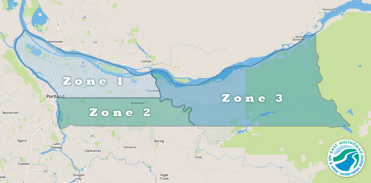
- The East Multnomah Soil and Water Conservation District is divided into three zones, which are shown here.
1 አካባቢ
 ዞን 1 ማልትኖማህ ካውንቲ ከ Willamette Base Line (Willamette Meridian) በስተሰሜን ከዊላምቴ ወንዝ እስከ ሳንዲ ወንዝ ድረስ ይገኛል።
- ሰሜን: ኮሎምቢያ ወንዝ፣ ማልትኖማህ ካውንቲ፣ ኦሪገን እና ክላርክ ካውንቲ፣ ዋሽንግተንን የሚለየውን መስመር ተከትሎ
- ደቡብ: Willamette Base Line (T.1N – T.1S township line) ስታርክ ስትሪት በዊላምቴ ቤዝ መስመር በኩል ወደ ሳንዲ ወንዝ ይደርሳል። ስታርክ ስትሪት ከወንዙ በስተደቡብ በስተምዕራብ በኩል ጥምዝ ያደርጋል። የመሠረት መስመር በምስራቅ ይቀጥላል. የዞኑ ወሰን የመሠረት መስመር ነው.
- ምስራቅ: የሳንዲ ወንዝ ዋና ሰርጥ
- ምዕራብ: የ Willamette ወንዝ ዋና ሰርጥ
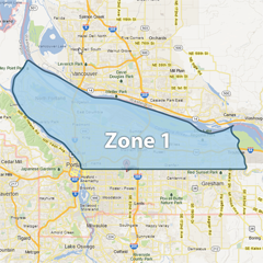
2 አካባቢ
 ዞን 2 ከ Willamette Base መስመር በስተደቡብ የሚገኘውን የማልትኖማ ካውንቲ ከዊልሜት ወንዝ እስከ ሳንዲ ወንዝ ድረስ ያካትታል።
- ሰሜን: Willamette Base Line (T.1N - T.1S የከተማ መስመር)
- ደቡብ: Multnomah County – Clackamas County መስመር (የክፍል መስመር)
- ምስራቅ: የሳንዲ ወንዝ ዋና ሰርጥ
- ምዕራብ: የ Willamette ወንዝ ዋና ሰርጥ, Ross Island በዚህ ዞን ውስጥ ተካትቷል.
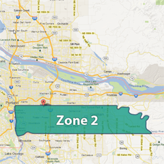
3 አካባቢ
(ሁሉም የመጀመሪያ ካርታ ምስሎች © Google 2013 ናቸው)
ዞን 3 ከአሸዋ ወንዝ በስተምስራቅ የሚገኘውን የማልትኖማህ ካውንቲ ያካትታል።
- ሰሜን: ኮሎምቢያ ወንዝ፣ በMultnomah County፣ Oregon እና Clark County፣ Washington መካከል ያለውን መስመር ተከትሎ
- ደቡብ: Multnomah County-Clackamas County መስመር (የክፍል መስመር)
- ምስራቅ: Multnomah ካውንቲ-ሁድ ወንዝ ካውንቲ መስመር
- ምዕራብ: የሳንዲ ወንዝ ዋና ሰርጥ